Valparai – Athirappilly Forest Loop
Coimbatore → Pollachi → Valparai (40 hairpins) → Malakkappara forest road → Athirappilly Falls → Thrissur → Palakkad → Coimbatore. ~400 km in a day, billed as South India's most dangerous road.
A one-day loop that climbs the famous 40-hairpin Valparai ghat, then takes the narrow Valparai–Malakkappara–Athirappilly road across the Anamalai and Sholayar forests — 85–90 km of single-lane tarmac with no fuel, no phone signal and a very real chance of elephants. It drops to Athirappilly Falls, Kerala's biggest waterfall, and returns to Coimbatore across the plains via Thrissur and the Palakkad gap.
Route idea: @withgowtham on Instagram / YouTube — 'South India's most dangerous road — 400 km in a 1-day trip'
The route
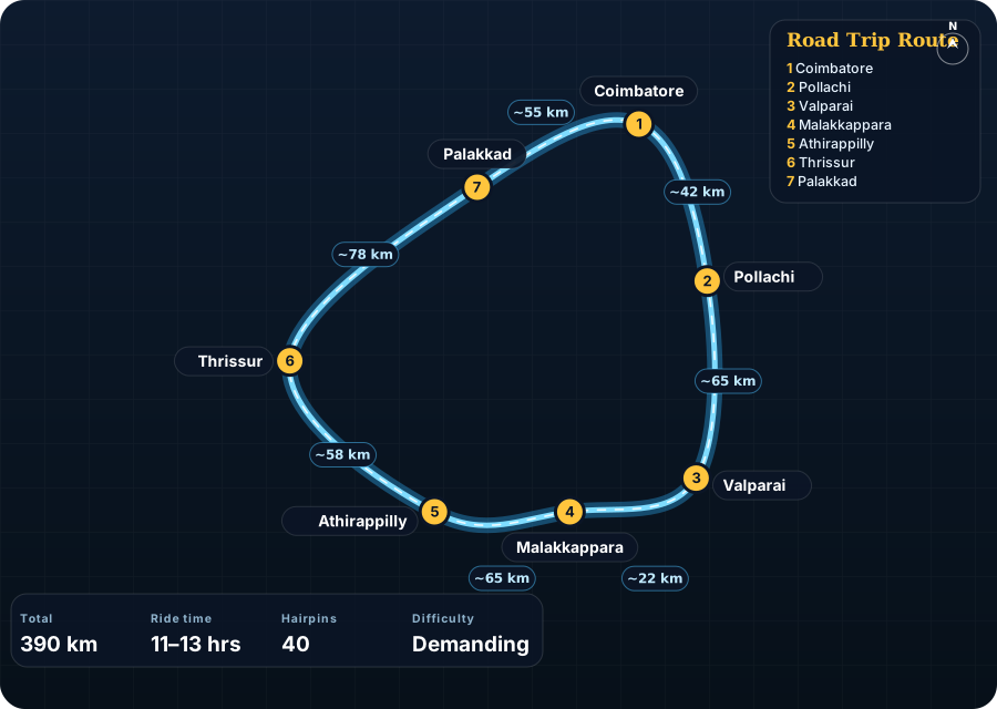
Schematic map generated from waypoint coordinates — the shape follows the geography (compressed so long legs don't squash the loop), distances are labelled per leg. Not a navigation map. Download the graphic.
Leg by leg
| # | Leg | Dist | Notes |
|---|---|---|---|
| 1 | Coimbatore → Pollachi Coimbatore – Pollachi (NH 83) | 42 km | Flat, fast, coconut country. Have breakfast in Pollachi; it's the last big town before the hills. tarmac |
| 2 | Pollachi → Valparai Pollachi – Aliyar dam – Valparai ghat (SH 78) | 65 km | The 40 numbered hairpins start after Aliyar dam. Loop view point at hairpin 9. Lion-tailed macaques near the top. 40 hairpins tarmac |
| 3 | Valparai → Malakkappara Valparai – Sholayar dam – Malakkappara | 22 km | Tea estates give way to forest. Tamil Nadu forest check post; Kerala check post at Malakkappara. narrow tarmac |
| 4 | Malakkappara → Athirappilly Malakkappara – Sholayar – Vazhachal – Athirappilly | 65 km | The 'dangerous' bit: single lane, blind bends, sheer drops, monsoon damage, elephants. No fuel, no signal, no food until Vazhachal. narrow, broken in places |
| 5 | Athirappilly → Thrissur Athirappilly – Chalakudy – Thrissur (SH 21 / NH 544) | 58 km | Back on wide roads. Athirappilly Falls viewpoint is a short walk from the parking. tarmac |
| 6 | Thrissur → Palakkad Thrissur – Palakkad (NH 544) | 78 km | Four-lane highway through the Palakkad gap. Fast. tarmac |
| 7 | Palakkad → Coimbatore Palakkad – Walayar – Coimbatore (NH 544) | 55 km | Kerala–Tamil Nadu border at Walayar; traffic thickens into Coimbatore. tarmac |
Highlights
- The 40 hairpins from Aliyar dam to Valparai — each one numbered, with the Loop view point looking back over the dam.
- Valparai tea estates and the Sholayar reservoir, one of the deepest dams in Asia.
- The Malakkappara–Athirappilly forest road: 60-odd km of canopy, hornbills, gaur and the occasional elephant.
- Athirappilly Falls — 80 ft wide, thundering in the months right after the monsoon.
- Vadakkunnathan Temple in Thrissur and Palakkad Fort if you have daylight to spare.
Off-road & motorcycling notes
Tarmac all the way, but the forest stretch is single-lane, badly patched in places and completely unsupported. This is where an ADV with decent ground clearance and knobbly-ish tyres earns its keep.
- Valparai ghat hairpins are tight but well-surfaced; the danger is estate buses and Tempo Travellers taking the whole road.
- Malakkappara–Athirappilly: potholes and landslide scars, moss on the shaded sections, and gravel at the culverts. Standing on the pegs helps.
- Zero fuel between Valparai and Chalakudy (~120 km). Fill to the brim in Valparai.
- Zero mobile signal in the forest; download offline maps for the whole loop.
- Ride in a group of at least two bikes on the forest stretch — a breakdown there is a long wait.
Timings, permits & fuel
- Forest check posts on the Valparai–Athirappilly road allow two-wheelers roughly 6:00 AM – 4:00 PM only (four-wheelers until 6:00 PM). Be at the Valparai side check post well before 3 PM.
- No advance permit; small entry fee (₹20–30 for two-wheelers) and ID check at the check posts.
- The forest road is closed intermittently after landslides in the monsoon (Jun–Sep) — check current status before leaving Pollachi.
- Fuel: Pollachi, Valparai (last before the forest), then Chalakudy / Athirappilly town. Palakkad and Coimbatore are plentiful.
Cautions
- Elephants and gaur on the forest road — this stretch has regular human–wildlife incidents. Stop, engine off, reverse if needed. Never get between a calf and the herd.
- Do not attempt the forest crossing in rain or fog; the drops are unguarded.
- Leave Coimbatore by 5 AM to make the check-post cut-off with time for the falls.
- The 'most dangerous road' tag is about isolation and wildlife more than the surface — respect it.
Along the way
.jpg)
Wikimedia Commons (free licence — see file page)

Wikimedia Commons (free licence — see file page)

Wikimedia Commons (free licence — see file page)
.jpg)
Wikimedia Commons (free licence — see file page)

Wikimedia Commons (free licence — see file page)

Wikimedia Commons (free licence — see file page)

Wikimedia Commons (free licence — see file page)

Wikimedia Commons (free licence — see file page)